Mesh files
The mesh is specified by three files located in MeshPath.
nod2d.outThe first line states the number of nodes. The following lines define one node each by three, optionally four, entries seperated by one or more spaces
optional: index of this node (Fortran style, counting starts with 1),
longitude [°E] or x-coordinate [m],
latitude [°N] or y-coordinate [m],
node type: Inner node (
0), closed boundary (1), open boundary (2), some special treatment (3-…)In particular, node type
3are regarded as nodes exactly on the coastline. When smoothing the topography, the topography at these nodes is kept at 0m.
nodhn.outor set TopoFile in namelist- The bathymetry and topography at each node is usually given in
nodhn.out, though this filename may be changed in the namelist to allow for an easy comparison of different geography data sets. Each line contains one value, the water depth [m] at the corresponding node. Notice that negative values mean elevation, thus land nodes. elem2d.out- The third file
elem2d.outdefines the elements, i.e., the triangular connection between the nodes. The first line contains the number of elements. The following lines define the elements by stating the three corresponding node indicees in counter clockwise ordering.
Further arrays e.g., for edges, neighbourhood relations, or boundary nodes, are built by TsunAWI on start up.
Here is a small example mesh. See also Examples and small test cases for a link to download test cases ready with namelist and meshes.
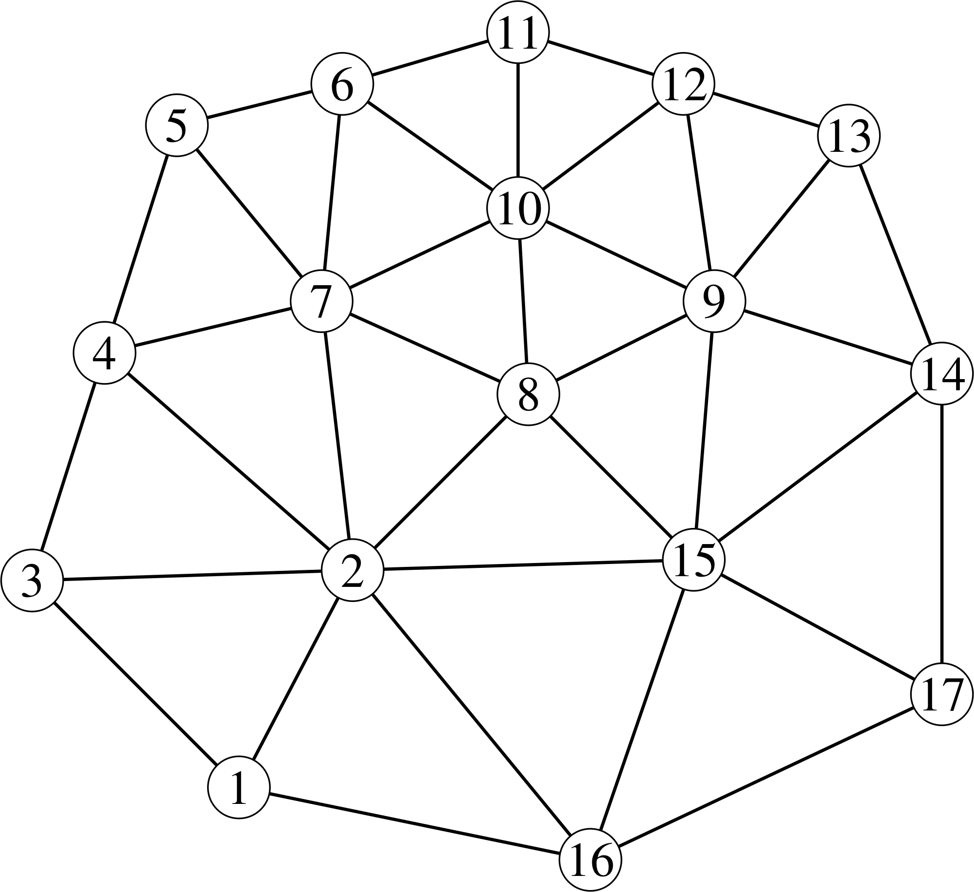
which is specified by
nod2d.out |
elem2d.out |
nodhn.out |
|---|---|---|
171 -2.7 -3.8 12 -1.6 -1.7 03 -4.7 -1.8 14 -4.0 0.4 05 -3.3 2.6 16 -1.7 3.0 17 -1.9 0.9 08 0.1 0.0 09 1.9 0.9 010 0.0 1.8 011 0.0 3.5 112 1.6 3.0 113 3.2 2.5 114 4.1 0.2 115 1.7 -1.6 016 0.7 -4.5 117 4.1 -2.9 1 |
221 2 31 16 22 4 32 7 42 8 72 15 82 16 154 7 55 7 66 7 106 10 117 8 108 9 108 15 98 15 99 12 109 13 129 14 139 15 1410 12 1114 15 1715 16 17 |
18.12.20.8.0.-4.0.0.-1.-2.-6.-1.3.8.7.22.25. |
(Right click on the headers to download the files.)